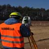
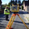
Home - Centremaps provide OS maps, land and measured building surveys, underground services surveys, ground penetrating radar, drainage connectivity and cctv condition surveys. Planning application maps, Drainage surveys, Height Data, Environmental reports
Providing great value maps, mapping and map data for business and leisure customers. An Ordnance Survey Options outlet and Licensed Partner.
#скейтеры
классика
воспоминания
компьютерные игры
Home - Height data, Ordinance Survey maps, Land Surveying, Land Survey, Height data, environmental reports, GPR Surveys, Planning application maps, Topographical Surveys, OS Maps online, Topographical Survey.
Centremaps is located in the Leigh area of Worcestershire. There are at least 2 other listings in the WR6 postcode area.
Surveyors in Worcestershire WR6